
Mobile GIS + The iPad = Public Works Transformation
By Brian Albright, Field Technologies magazine
This South Carolina county has optimized field operations by extending GIS technology to its fleet of iPads.

Local governments form a web of interconnected services and departments that have an impact on every citizen, every day. Federal institutions may get all the attention, but city and county agencies are the nexus where the public and the government rub elbows, literally and figuratively. And as every public-facing business owner knows, service in that context is critical.
Increasingly, technology has played a large role in helping these institutions do their public duty. In Horry County, SC, for instance, geographical information system (GIS) technology is helping every agency, from the county council to the assessor’s office, do its job more efficiently.
GIS underpins nearly every line of business system in Horry County, home to more than 250,000 people. Located in the northeastern corner of the state, the county has been using GIS data for its operations since 2000. “Everything we do is integrated into GIS, from 911, to permitting, to stormwater, to assessment,” says Timothy Oliver, the county’s GIS officer and assistant CIO.
The county uses the Esri ArcGIS mapping platform as the basis for a number of location-based systems. They have also rolled out OnBase document and management software from Hyland Software (an Esri partner) that integrates documents (in this case, things like permits, photos, police incident reports, etc.) with mapping data so that users can retrieve the documents via the map in the application.
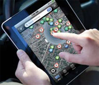
Over the past few years, the county has taken its GIS data mobile, rolling out more than 450 iPads to employees in the fire and police departments, county council members, building inspectors, code enforcement officers, stormwater management employees, and others. In the process, the county has reduced its reliance on paper documents, provided an easy way for employees in the field to access records, and made operations more efficient.
“We can show live 911 call data at the map level for public safety officers or live work order data for the stormwater division,” Oliver says. “If a building inspector is standing at a location where they have an inspection, and they look across the street and see work being done on a property, they can use the map to find out if a permit has been issued. All of that live, line-of-business data is available across the enterprise.”
iPad Deployment Spurs Innovation
Expansion of the GIS data to the field was actually spurred by the purchase of a handful of iPads. The first batch of tablets was issued to the county council so they could access council meeting agendas online. According to Oliver, these documents were hundreds of pages long, and 25 to 30 copies had to be printed and distributed every two weeks. “They wanted a way to reduce the time and energy involved with that process,” Oliver says. “A sheriff actually had to hand deliver all of those agendas.”
The IT staff came up with a solution using Adobe Professional and Dropbox to provide online access to the agendas. The council members, however, quickly discovered they wanted to do more with the new devices. “The first complaint we had from the council was that they couldn’t access the GIS data from the iPad,” Oliver says. “At that time, our GIS website did not function with the iPad, so we were pushed by the council to make that available to them.”
That summer, when Oliver attended an Esri user conference, he approached Esri staff and explained that he needed to be able to access the mapping applications via the tablet. “The guy asked if we had any services or maps that were exposed, and he showed me how to use ArcGIS Online, an interactive mapping platform from Esri, which would allow us to deploy GIS on the iPhone and iPad. It took him ten minutes to show me how to do it.”
Back in his hotel room, Oliver spent the next few hours experimenting with the application. “I sent an email back to my staff asking them to check this out on their iPads,” Oliver says. “I had put up a parcel search on the website displaying our information. When I came back, we were able to embed maps on the county website.”
Three months after the iPads were delivered to county council, Oliver’s team began deploying devices to the public safety department. “The initial thrust of that, again, was making documents available via Dropbox,” Oliver says. The public safety assistant county administrator wanted to be able to access situational awareness data (hurricane information, satellite information for fires, 911 calls, etc.) on the iPads. However, because Flex requires Adobe Flash, that solution cannot be used in conjunction with the iPad. To get around this, the team used ArcGIS Online as a portal to create maps and pass those back down to the mobile devices using security groups they created in ArcGIS Online.
“Once we started making active 911 calls available via the maps on the iPad, we began looking at the cost associated with the mobile data terminals in the cruisers and seeing if we could replace those more expensive units with iPads, at least in some cases. After that, things started taking off,” Oliver says.
Since then, the mobile capability has been expanded to other departments, and development time for creating new mobile services has been reduced significantly. “The first map took a few hours to generate,” Oliver says. “Once staff learned how to do it, we’ve got that down significantly. We can create a new map and have it available in a half hour or less.”
GIS Requests Grow Exponentially
Once the public safety department saw what was possible with the iPads, other divisions quickly lined up to outfit their own mobile employees with the devices. “When people saw what we could do with it, the list of requests just grew exponentially,” Oliver says.
First up was stormwater management. “That was easy, because we had added stormwater work orders into the emergency management application already,” Oliver says. “When we are hit with a hurricane, the stormwater work order system is where all of the work orders go that are associated with that incident.”
To create a new service, the staff simply has to add data layers to the map and expose it in ArcGIS Online. They then create any pop-ups or queries that the end user might want included. “If we aren’t specifically requested to do something, we develop services that we think meet a need,” Oliver says. “Then we do a pilot with a few users to get feedback. We can spend an hour developing something and let them look at it. That’s what happened with fire department pre-plans. We brought in six firefighters and the chief, and showed this to them. Before they left, they had given us a list of a half dozen things they wanted added. We gave them two iPads for a beta test, and then the chief ordered 43 more so he could get everything put into the GIS system for all of the fire stations.
“Since we don’t need programmers, GIS techs can do the work of creating the application,” Oliver continues. “If we get a request, we can assign it to somebody, and by the end of the day we usually have something they can test, if not deploy.”
The GIS department purchases, provides, and distributes all of the iPads across every department. “We configure them; we set up all the accounts and download all of the apps that we’ve purchased for the devices,” Oliver says. “We also set up the user profiles and handle all of the training.”
All of the devices are protected using rugged cases from OtterBox or Griffin Technology. “Since we went live, of the 450 out there we’ve only had three of them dropped and had to replace the glass on them,” Oliver says. “We also had three stolen. We can pull back all of our information and lock them down remotely when that happens.”
Editing Data From The Field
As other departments have provided input, Oliver’s team has been able to add even more functionality. For instance, when the code enforcement division wanted the ability to see documents on the map associated with specific structures and parcels, the IT department was able to use the OnBase solution to provide that access. Once people saw how much information was available this way, requests started coming in for a more interactive experience.
“The more we roll this out, the more people want to be able to edit data in the field,” Oliver says. “They want to change data and see those edits in real time. It was something of a surprise to see how many people who are not GIS technicians want to have an impact on and input data into the GIS enterprise system.”
One example: fire department pre-plans, which provide important facility information to the fire department before it arrives at a location. “We have 43 fire stations, and all the pre-plans were printed on paper and had to be maintained in three-ring binders,” Oliver says. “If a change was made, they had to make and distribute copies for all the stations. We created an editing app so they can put a dot on a map, attach pictures, add documents, and put in key information, such as where a new fire hydrant was installed. They also added all the floor plans for all the schools in the county.”
That change eliminated the large binders, as well as made it easier to distribute updates across the fire department. To ensure that only authorized and trained personnel make those edits, the GIS team can create security groups within ArcGIS Online and provide access to just those designated staff members.
That type of data access has real-world consequences. In 2009, a large forest fire burned 20,000 acres in Horry County. “The GIS team couldn’t keep up with the paper map requests related to that fire,” Oliver says.
This year, the fire department responded to another large blaze, and the experience was much different. Using the iPads, officials were quickly able to update the maps with assessed damage values, the location of damaged structures, and photos of the buildings. “Within 30 minutes of arrival on the scene, all of the incident information was available on the iPads,” Oliver says. “Previously, that would have taken a whole team to come down and work for four or five hours just to get the damage assessments completed. This is the only way we could provide first responders and decision makers with that kind of data.”
The benefits of extending the GIS data to mobile devices have varied by department. In the case of the fire department, the mobile devices provide access to critical information (like fire hydrant locations and floor plans) prior to a truck’s arriving at the scene of a fire and without the hassle of rummaging through a large binder. Police personnel can view up-to-date information about 911 calls and see historical data about the location via the map, without having to call a dispatcher or access other applications. They can even access information from nearby traffic cameras through the map.
Building inspectors can automatically search parcel records on the iPads. Before, they would have had to call an office and ask a clerk to search for that data on the desktop system. Data for the 250,000 parcels the county maintains can be accessed and updated in real time, by any department. That helps enable everything from property assessments to hurricane preparation.
“We consider GIS to be mission-critical,” Oliver says. “All we do is defined by geography. We are constantly pushing the envelope to see how far we can take this.”
HTML5 Takes Mobile Solution To The Next Level
The system has continued to evolve. Richmond, VA-based integrator The Timmons Group is working with the county on its new Integrated Regional Information Sharing System (iRISS), with the company providing new rolebased authentication, HTML5 and javascript, and Esri integration support. The Motorola 911 dispatch system feeds for fire and rescue have been integrated with that solution, which will provide archival data views and even earthquake tracking.
Timmons Group also developed an HTML5-based dashboard, so that staff can view emergency data in the field, such as the closest on-duty officers, nearest hospitals, hydrant locations, traffic camera data, etc. That system will eventually supplant the existing situational awareness solution for the mobile devices.
“Everything else we’ve been doing on the iPad has been using the Esri application for mobile,” Oliver says.
“The iRISS website that Timmons has worked with us on is browser-based. It will take us a giant leap forward because we have all this actionable intelligence built in. First responders won’t have to turn on and off different application layers to see the information. If they touch an incident on the map, all of the data will be automatically provided to them. If it’s a commercial structure fire, it will automatically show them all the Tier Two hazardous chemical reports, the locations of any critical facilities or hospitals nearby, wind direction, and wind speed. Before, they had to drill down to get to that information.”
The GIS data will be integrated with the new enterprise resource planning (ERP) system the county plans to deploy in the next few years. Oliver says the county also plans to deploy a new mobile device management (MDM) solution in order to meet the requirements for providing access to the FBI’s Criminal Justice Information Services (CJIS) system. “They have pretty tight security requirements, but the FBI has accepted tablets and iPads as acceptable for meeting compliance,” Oliver says. “They have some minor requirements from an MDM standpoint, and we’ll be able to meet those by the end of this year.”
The county is also working on a GIS-enabled business licensing system (that has to be migrated from a legacy AS400 application), and a county asset management solution. “When we move to our new ERP system, that asset information will be integrated with that software,” Oliver says. “That’s going to include data on assets like computers and other equipment that might not necessarily be included in the mapping data otherwise.”
Oliver expects to continue developing even more GIS services for the iPads as end users and the GIS staff find additional ways to leverage the data in the field. “Our philosophy is that GIS has to provide a benefit,” Oliver says. “We have to demonstrate the value of GIS to end users and make it work for them.”
Taking GIS Data To The Field
As Horry County, SC investigated ways to extend the functionality of the map-based data generated by its Esri ArcGIS platform, one key piece of functionality that end users across divisions wanted was the ability to access documents and other content related to a specific location from the GIS map view.
 To enable that functionality, as well as get a better handle on a variety of county documents, the county deployed the OnBase enterprise content management (ECM) solution from Hyland Software, an Esri partner. Prior to OnBase, manual document handling processes often resulted in lost documents and inefficient processes.
OnBase can be used to capture data from both paper and electronic documents in a single, secure repository and then share data with other systems. OnBase is integrated with the GIS system, as well as some of Horry County’s other legacy applications. All documents are stored digitally, and employees can access them through a single interface.
Documents can also be accessed via GIS maps, both on a desktop PC and via a mobile device like the iPads the county has deployed. By clicking on a parcel, employees (such as code enforcement officials) can access associated documents and content. “All of the documents are there,” says Timothy Oliver, GIS officer and assistant CIO for Horry County. “They are linked to the location via the parcel number.”
The county is now in the process of migrating to an HTML5-based mobile solution. The HTML5-based solution will allow even more seamless access to data from the GIS-based applications that employees can use in the field. The OnBase/GIS integration will help ensure that all relevant data and documents related to a location are accessible, no matter where they are needed.
For more information on the Esri ArcGIS platform and other GIS solutions the company provides, visit www.esri.com.
Want more content like this?
Click here to subscribe to our FREE print magazine.